 |
|
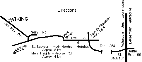
How to get to Viking
• Montreal, take the Laurentian Autoroute (route 15) north to exit 60 for St. Sauveur/Morin-Heights.
• Turn left across the highway and bear right after crossing
the bridge.
• Proceed along route 364 through St. Sauveur about
8 km to the traffic lights in Morin Heights.
• Turn left at the traffic lights and proceed along
route 329 about 4 km to dual sign Perry / Jackson on
the right hand side of the road.
• Turn right at the Perry / Jackson sign, and immediately
after, left to continue on Jackson Road.
• About one km along you will see the Club house and parking
lot on your right.
Address: 393 Jackson, Morin-Heights
GPS coordinates: 74.290387 W, 45.869118 N (Longitude: 74° 17’ 25.4” W, Latitude: 45° 52’ 8.8” N)
Click here for a more detailed map
|